URBAN DEVELOPMENT PROJECT

The final Giga Map

Location of Breivoll in Oslo
Project Description
Breivoll is an industrial area in the outskirts of Oslo (see image above). Breivoll has gone through a rich historic evolution going from agriculture activities to logging, followed by a technological evolution and the introduction of the train line to mention the main transitions. Breivoll has always been an area where some type of production was present. Today Breivoll is a fragmented industrial area with a lack of identity. To prevent Breivoll from becoming a degraded area and enabling the area to live up to its full potential a group of interdisciplinary stakeholders among which Oslomet product design Master students and the non-profit organization Pådriv collaborate to make sure sustainable urban development will take place in the future.

Mapping the historical evolutions that took place at Breivoll

Satellite Map of Breivoll year 2023

A map of the different type of zones and buildings at Breivoll to visualize how this area is fragmented in different zones
Pådriv
Pådriv is a non-profit organization that strives for sustainable urban development to ensure social development, quality of living, protection of the environment and economic development. Pådriv achieves this by collaborating with interdisciplinary stakeholders who share an interest in the area in development and introduce tangible change from the bottom-up.

Mapping the relations between stakeholders of the project, identify areas that can be improved and recognize which different expertise are part of the interdisciplinary team to propose efficient and good use of expertise for maximum result.
Project Objective
The objective is to use GIGA mapping (systems mapping) to visualize data and the dynamics within complex systems associated with the area of Breivoll in order to accumulate, communicate, and interrelate data. This permits us to get an understanding of the wickedness of real-life complex relations that define the area of Breivoll. Methods such as observations, mapping of situations, design probing, play probing, interviews, social mapping, cybernetic analysis are used to reveal hidden systems and information that are part of the composition of Breivoll. This higher level of understanding can lead to the identification of elements that work well within a system and potential intervention points to introduce change.
This approach is important to identify the heritage of Breivoll that needs to be preserved, generate holistic resolutions, increase the possible solutions by keeping as many aspects of the problem field at play and to expose potential approaches on how the existing systems can be used or adapted to accommodate social engagement and a harmonious synergy between industry and housing, work and leisure to ensure relevant durable change for a future proof Breivoll.

Noise Pollution & Public Transport

Section Cuts Map: topography and physical barriers in the area

Topography and physical barriers in the area

Trash Zones: Identify areas where people litter these are usually areas that need to be reinvented and get a unique identity so people start to care for this place.

Desire Paths: these are paths and trails that show us how people want to use the area.

Insights based on observations on the terrain
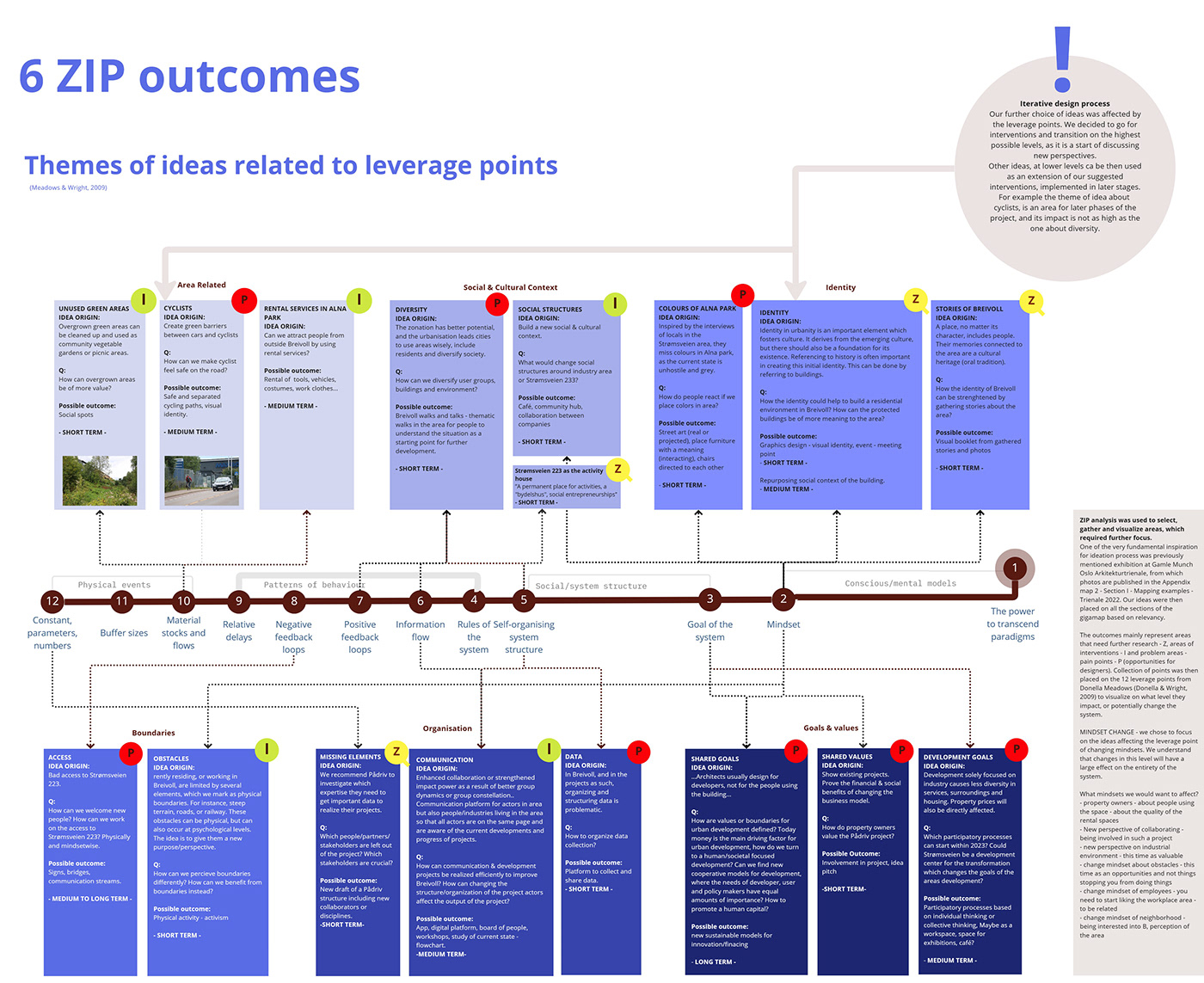
Using the 12 leverage points from Donella Meadows to identify areas of intervention, problem areas or areas that need further investigation
